1963 Map of Mc Kenney
USGS Topo · Published 1972About this map
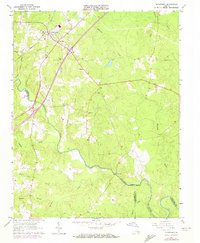
McKenney serves as the primary hub in this 1963 survey, situated where the Seaboard Coast Line Railroad cuts through the rural landscape of southern Virginia. The community is anchored by a local High Sch and several country churches, including Asbury Ch and Big Bethel Ch. The terrain is deeply carved by a network of drainage systems, most notably the Nottoway River, which forms the boundary between Dinwiddie and Brunswick counties.
Find a feature on this map
27 named features on this map. Tap any name to fly to it.
Don’t see what you’re looking for? This feature index may not catch every label — zoom into the map to look around manually.
Map Details
Editions of this 1963 Mc Kenney Map
2 editions found
Other maps of this area

1897 · Amelia
USGS Topo · 1:125,000

1918 · Lawrenceville
USGS Topo · 1:62,500

1919 · Mc Kenney
USGS Topo · 1:48,000

1920 · Lawrenceville
USGS Topo · 1:48,000

1921 · Mc Kenney
USGS Topo · 1:62,500

1921 · Lawrenceville
USGS Topo · 1:62,500

1942 · Lawrenceville
USGS Topo · 1:62,500

1943 · Mc Kenney
USGS Topo · 1:62,500

1943 · De Witt
USGS Topo · 1:24,000
1943 · Dinwiddie
USGS Topo · 1:24,000