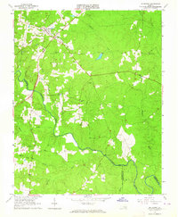
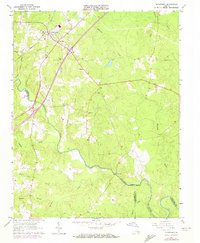
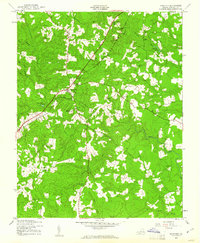
1963 Map of Mc Kenney
USGS Topo · Published 1964About this map
The town of McKenney serves as the central hub of this 1963 survey, where the Seaboard Air Line railroad and local roads converge. The landscape is a network of small creeks including Buckskin Creek, Sappony Creek, and Smith Creek, all draining toward the prominent Nottoway River. For genealogists and local historians, the map is remarkably dense with family-named landmarks and rural burial sites, such as Fitzgerald Cem, Abernathy Cem, and Madison Cem.
Find a feature on this map
30 named features on this map. Tap any name to fly to it.
Don’t see what you’re looking for? This feature index may not catch every label — zoom into the map to look around manually.
Map Details
Editions of this 1963 Mc Kenney Map
2 editions found
Other maps of this area

1897 · Amelia
USGS Topo · 1:125,000

1918 · Lawrenceville
USGS Topo · 1:62,500

1919 · Mc Kenney
USGS Topo · 1:48,000

1920 · Lawrenceville
USGS Topo · 1:48,000

1921 · Mc Kenney
USGS Topo · 1:62,500

1921 · Lawrenceville
USGS Topo · 1:62,500

1942 · Lawrenceville
USGS Topo · 1:62,500

1943 · Mc Kenney
USGS Topo · 1:62,500

1943 · De Witt
USGS Topo · 1:24,000
1943 · Dinwiddie
USGS Topo · 1:24,000