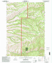
1995 Map of Mc Kinzie Creek
USGS Topo · Published 1999About this map
Nez Perce National Forest dominates this Idaho landscape, where high ridgelines and deep drainages define the remote character of the Salmon River country. The 1995 survey details a region managed for both resource use and conservation, evidenced by Wild Horse Corrals and the Slate Creek Work Center (Site) in the southern portion of the quadrangle. The topography is a complex system of ridges, including Banner Ridge, Gabe Ridge, and Delmage Ridge, which separate various branches of the river system.
Find a feature on this map
29 named features on this map. Tap any name to fly to it.
Don’t see what you’re looking for? This feature index may not catch every label — zoom into the map to look around manually.
Map Details
Editions of this 1995 Mc Kinzie Creek Map
This is the sole edition of this map. No revisions or reprints were ever made.
Other maps of this area

1955 · Grangeville
USGS Topo · 1:250,000

1959 · Grangeville
USGS Topo · 1:250,000

1963 · John Day Mtn
USGS Topo · 1:24,000

1963 · Lucile
USGS Topo · 1:24,000

1963 · McKinzie Creek
USGS Topo · 1:24,000

1963 · Goodwin Meadows
USGS Topo · 1:24,000

1963 · White Bird Hill
USGS Topo · 1:24,000

1963 · Slate Creek
USGS Topo · 1:24,000
1963 · Dairy Mountain
USGS Topo · 1:24,000

1963 · White Bird
USGS Topo · 1:24,000