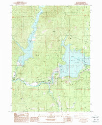
1988 Map of Mc Leod
USGS Topo · Published 1988About this map
Lost Creek Lake and the newly forming Elk Creek Lake dominate this Jackson County landscape, reflecting a period of major hydrologic and recreational transformation along the Rogue River. The 1980s data shows the footprint of reservoir development, including infrastructure like the Powerhouse, Intake Tower, and Spillway. Near the small settlement of McLeod, the Cole M. Rivers Fish Hatchery stands as a significant facility for river management, complemented by several public recreation areas such as McGregor Park and Joseph Stewart State Park. Historically significant sites such as the Elk Trail Sch and the McLeod Guard Sta provide points of interest for genealogists and local historians tracking early forest service and educational presence in the area. High points like Tatouche Peak and Fawn Butte rise above the complex network of creeks, including Big Butte Creek and Middle Creek.
Find a feature on this map
40 named features on this map. Tap any name to fly to it.
Don’t see what you’re looking for? This feature index may not catch every label — zoom into the map to look around manually.
Map Details
Editions of this 1988 Mc Leod Map
2 editions found
Other maps of this area

1891 · Ashland
USGS Topo · 1:250,000

1893 · Ashland
USGS Topo · 1:250,000

1897 · Ashland
USGS Topo · 1:250,000

1943 · Trail
USGS Topo · 1:62,500

1944 · Tiller
USGS Topo · 1:62,500

1944 · Abbott Butte
USGS Topo · 1:62,500

1947 · Abbott Butte
USGS Topo · 1:62,500

1954 · Butte Falls
USGS Topo · 1:62,500

1955 · Medford
USGS Topo · 1:250,000

1957 · Medford
USGS Topo · 1:250,000