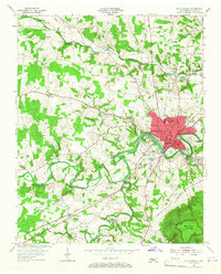
1953 Map of Mc Minnville
USGS Topo · Published 1967About this map
Mc Minnville serves as the focal point of this mid-century Warren County landscape, situated at the confluence of the Barren Fork and Hickory Creek. The town's grid expands around the St Louis and San Francisco RR and Main St, showing a thriving hub complete with a golf course, fair grounds, and several local schools like Biles Sch and Bernard Sch. Beyond the town limits, the terrain transitions into a more rural pattern of small settlements and family landmarks.
Find a feature on this map
81 named features on this map. Tap any name to fly to it.
Don’t see what you’re looking for? This feature index may not catch every label — zoom into the map to look around manually.
Map Details
Editions of this 1953 Mc Minnville Map
4 editions found

Other maps of this area

1893 · Mc Minnville
USGS Topo · 1:125,000

1895 · Mc Minnville
USGS Topo · 1:125,000

1936 · Morrison
USGS Topo · 1:24,000

1942 · Statesville
USGS Topo · 1:100,000

1943 · Cookeville
USGS Topo · 1:100,000

1943 · Mc Minnville
USGS Topo · 1:100,000

1944 · Cookeville
USGS Topo · 1:100,000

1952 · Centertown
USGS Topo · 1:24,000

1953 · Chattanooga
USGS Topo · 1:250,000

1953 · Centertown
USGS Topo · 1:24,000