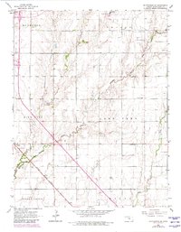
1965 Map of Mc Pherson SE
USGS Topo · Published 1980About this map
Elyria serves as the primary settlement center on this mid-1960s survey, situated along the Missouri Pacific railroad line and a local Roadside Park. The landscape is a mix of agricultural plots and petroleum extraction, most notably within the Canton Oil Field and the Ritz area, where numerous Oil Wells are interspersed among township sections. Water drainage is defined by the winding paths of Running Turkey Creek and Sand Creek, which carve through the townships of Empire, King City, and Lone Tree.
Find a feature on this map
21 named features on this map. Tap any name to fly to it.
Don’t see what you’re looking for? This feature index may not catch every label — zoom into the map to look around manually.
Map Details
Editions of this 1965 Mc Pherson SE Map
4 editions found
Other maps of this area

1889 · Newton
USGS Topo · 1:125,000

1891 · Hutchinson
USGS Topo · 1:125,000

1893 · Hutchinson
USGS Topo · 1:125,000

1894 · Newton
USGS Topo · 1:125,000

1955 · Hutchinson
USGS Topo · 1:250,000

1959 · Hutchinson
USGS Topo · 1:250,000

1965 · Mc Pherson South
USGS Topo · 1:24,000

1965 · Galva
USGS Topo · 1:24,000

1965 · Halstead NW
USGS Topo · 1:24,000
1965 · Mc Pherson SE
USGS Topo · 1:24,000