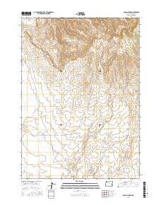
2017 Map of McCain Creek
USGS Topo · Published 2017About this map
McCain Creek carves through the high desert landscape of Malheur County, Oregon, defining a region where water management and cattle ranching shape the geography. This 2017 survey highlights a network of essential water sources including McCain Reservoir Number One, McCain Reservoir Number Two, and Shell-Rock Reservoir. These catchments, along with named springs like Upper McCain Springs and Moonshine Spring, represent the vital infrastructure of the high rangeland. The terrain is marked by significant elevations, notably Mahogany Mtn and distinctive formations such as The Tongue. This area is accessed primarily by unpaved tracks like Mahogany Rd and Blowout Reservoir Rd, which traverse the open range between Gunsight Pass and Hon Gulch. The map provides a detailed view of the drainage patterns for Schnable Cr and Cove Cr, essential for understanding the hydrology of this arid corner of the state.
Find a feature on this map
25 named features on this map. Tap any name to fly to it.
Don’t see what you’re looking for? This feature index may not catch every label — zoom into the map to look around manually.
Map Details
Editions of this 2017 McCain Creek Map
This is the sole edition of this map. No revisions or reprints were ever made.
Other maps of this area

1955 · Boise
USGS Topo · 1:250,000

1958 · Boise
USGS Topo · 1:250,000

1962 · Boise
USGS Topo · 1:250,000

1967 · Diamond Butte
USGS Topo · 1:24,000
1967 · Bannock Ridge
USGS Topo · 1:24,000

1967 · Rooster Comb
USGS Topo · 1:24,000
1969 · Mahogany Gap
USGS Topo · 1:24,000

1969 · Jordan Craters South
USGS Topo · 1:24,000

1969 · Mc Cain Creek
USGS Topo · 1:24,000

1969 · Jordan Craters North
USGS Topo · 1:24,000