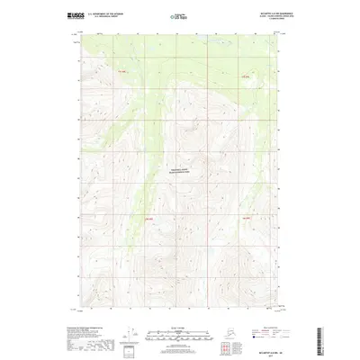
2017 Map of McCarthy A-8 NW
USGS Topo · Published 2017About this map
Wrangell-Saint Elias National Park encompasses the majority of this Alaskan wilderness, defined by steep elevational gradients and an intricate network of alpine drainage. The northern reaches are bounded by the Hanagita River, while the central and southern valleys are carved by Sangaina Cr and the multiple branches of Lake Cr. This topographic study reveals a landscape dominated by natural water systems and high ridges, notably devoid of permanent human settlements or road infrastructure during the 2017 survey. The layout of the township and range lines, such as t7s r8e and t8s r9e, provides the primary structural grid for this protected federal land, illustrating the vast scale of the park's interior.
Find a feature on this map
8 named features on this map. Tap any name to fly to it.
Don’t see what you’re looking for? This feature index may not catch every label — zoom into the map to look around manually.
Map Details
Editions of this 2017 McCarthy A-8 NW Map
This is the sole edition of this map. No revisions or reprints were ever made.
Other maps of this area

1950 · McCarthy A-8
USGS Topo · 1:63,360

1951 · McCarthy
USGS Topo · 1:250,000

1951 · Valdez B-1
USGS Topo · 1:63,360

1951 · Valdez A-1
USGS Topo · 1:63,360

1951 · McCarthy B-8
USGS Topo · 1:63,360

1952 · Valdez
USGS Topo · 1:250,000

1960 · McCarthy
USGS Topo · 1:250,000

1960 · Valdez
USGS Topo · 1:250,000

1995 · McCarthy B-8
USGS Topo · 1:63,360
1995 · Valdez B-1
USGS Topo · 1:63,360