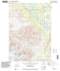
1995 Map of Valdez B-1
USGS Topo · Published 2002About this map
The Chitina River and its tributary, the Kuskulana River, dominate this Alaskan landscape, reflecting a geography shaped by glacial activity and high-altitude drainage. Compiled from 1950 topography and 1995 imagery, the map details a region where infrastructure is minimal, centered largely on the Mc Carthy Road in the northeastern corner. The presence of several isolated cabins suggests the seasonal or subsistence use of this wilderness area. Significant water bodies like Summit Lake and the winding Tebay River are primary landmarks within the Wrangell - Saint Elias National Park and surrounding Wrangell Saint Elias Wilderness. The map's labeling of numerous crevasses and a prominent Canyon underscores the dynamic and challenging physical environment that defines this portion of the Copper River Meridian.
Find a feature on this map
22 named features on this map. Tap any name to fly to it.
Don’t see what you’re looking for? This feature index may not catch every label — zoom into the map to look around manually.
Map Details
Editions of this 1995 Valdez B-1 Map
This is the sole edition of this map. No revisions or reprints were ever made.
Other maps of this area

1950 · McCarthy A-8
USGS Topo · 1:63,360

1951 · McCarthy
USGS Topo · 1:250,000

1951 · Valdez B-2
USGS Topo · 1:63,360

1951 · Valdez B-1
USGS Topo · 1:63,360

1951 · Valdez A-1
USGS Topo · 1:63,360

1951 · McCarthy C-8
USGS Topo · 1:63,360

1951 · Valdez C-2
USGS Topo · 1:63,360

1951 · McCarthy B-8
USGS Topo · 1:63,360

1951 · Valdez C-1
USGS Topo · 1:63,360

1951 · Valdez A-2
USGS Topo · 1:63,360