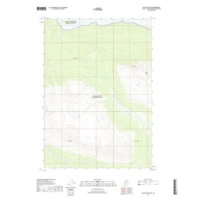
2017 Map of McCarthy B-8 SW
USGS Topo · Published 2017About this map
Wrangell-Saint Elias National Park and the adjacent Wrangell-Saint Elias National Preserve define this wilderness corridor in the Copper River valley region. The terrain is marked by significant elevation changes, rising toward the prominent Nelson Mtn in the east. This 2017 survey details a landscape dominated by braided glacial runoff and high-altitude drainage systems, where the broad path of the Chitina River serves as the primary northern boundary. Further south, the Hanagita River and its tributaries, including Sangina Creek and Grant Cr, carve through the valleys between steep ridges. The absence of roads or established settlements on this USGS quadrangle underscores the primitive state of the backcountry, providing a clear record of the area's natural hydrology and topographic relief as it remains today.
Find a feature on this map
11 named features on this map. Tap any name to fly to it.
Don’t see what you’re looking for? This feature index may not catch every label — zoom into the map to look around manually.
Map Details
Editions of this 2017 McCarthy B-8 SW Map
This is the sole edition of this map. No revisions or reprints were ever made.
Other maps of this area

1950 · McCarthy A-8
USGS Topo · 1:63,360

1951 · McCarthy
USGS Topo · 1:250,000

1951 · Valdez B-1
USGS Topo · 1:63,360

1951 · Valdez A-1
USGS Topo · 1:63,360

1951 · McCarthy B-8
USGS Topo · 1:63,360

1952 · Valdez
USGS Topo · 1:250,000

1960 · McCarthy
USGS Topo · 1:250,000

1960 · Valdez
USGS Topo · 1:250,000

1995 · McCarthy B-8
USGS Topo · 1:63,360
1995 · Valdez B-1
USGS Topo · 1:63,360