
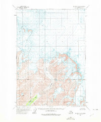
1960 Map of McCarthy D-8
USGS Topo · Published 1965About this map
Scotty Peak anchors the southern reaches of this 1960s study, standing above a landscape dominated by the movement of an expansive Glacier. The topography reflects a region shaped by glacial retreat and advancement, with numerous Crevasses marked throughout the ice fields. Water drainage is defined by the Kluvesna River, which flows through the southwestern corner, fed by tributaries including Fall Creek, Mineral Creek, and Surprise Creek. Based on 1957 aerial photography and 1960 field annotations, the map documents a transitional period in Alaskan surveying where photogrammetric methods began to capture high-altitude details. The presence of the Base Line survey marker indicates the fundamental land measurement systems being established in this part of the Alaskan wilderness. This map provides a technical view of the glaciated terrain before modern climate shifts significantly altered these perennial ice structures.
Find a feature on this map
9 named features on this map. Tap any name to fly to it.
Don’t see what you’re looking for? This feature index may not catch every label — zoom into the map to look around manually.
Map Details
Editions of this 1960 McCarthy D-8 Map
2 editions found
Other maps of this area

1950 · Nabesna
USGS Topo · 1:250,000

1951 · McCarthy
USGS Topo · 1:250,000

1951 · Gulkana
USGS Topo · 1:250,000

1951 · Nabesna
USGS Topo · 1:250,000

1951 · McCarthy C-8
USGS Topo · 1:63,360

1951 · Valdez C-1
USGS Topo · 1:63,360

1952 · Valdez
USGS Topo · 1:250,000

1953 · Valdez C-1
USGS Topo · 1:63,360
1959 · Gulkana A-1
USGS Topo · 1:63,360

1959 · Gulkana
USGS Topo · 1:250,000