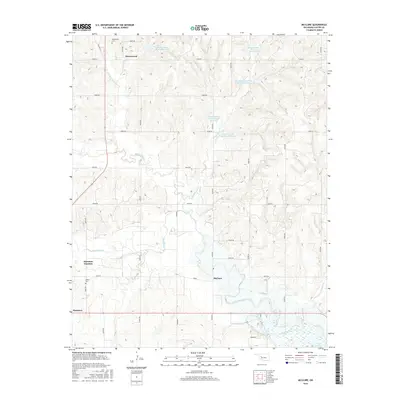
2016 Map of McClure
USGS Topo · Published 2016About this map
The Washita River meanders across this rural landscape in Roger Mills and Custer Counties, defining the drainage patterns for numerous small tributaries and man-made impoundments. The settlement of Hammon serves as a primary local hub, while the smaller community of McClure and the railroad-inflected Hammon Junction mark the path of local transit. Much of the northern terrain is shaped by the Quartermaster Creek watershed, featuring a series of conservation structures including Quartermaster Site 25 Reservoir and Quartermaster Creek Site 30 Reservoir. Genealogists and local historians will find value in the location of Moorewood Cem near the northern settlement of Moorewood, as well as Bethel Cem to the south. The southeastern corner of the quadrangle touches the upper reaches of Foss Reservoir, where Crooked Cr joins the main river system amidst a grid of established section roads like e0940 RD.
Find a feature on this map
37 named features on this map. Tap any name to fly to it.
Don’t see what you’re looking for? This feature index may not catch every label — zoom into the map to look around manually.
Map Details
Editions of this 2016 McClure Map
This is the sole edition of this map. No revisions or reprints were ever made.
Other maps of this area

1955 · Clinton
USGS Topo · 1:250,000

1957 · Clinton
USGS Topo · 1:250,000

1957 · Butler
USGS Topo · 1:62,500

1960 · Hammon
USGS Topo · 1:62,500

1961 · Leedey
USGS Topo · 1:62,500

1962 · Aledo
USGS Topo · 1:62,500

1976 · Butler NW
USGS Topo · 1:24,000

1976 · Butler SW
USGS Topo · 1:24,000
1983 · Foss Dam
USGS Topo · 1:24,000
1983 · Butler
USGS Topo · 1:24,000