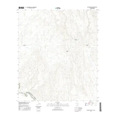
2016 Map of McComb Canyon
USGS Topo · Published 2016About this map
The Rio Grande serves as the international boundary in this remote stretch of West Texas and northern Mexico. On the northern bank, the arid landscape of Presidio Co is defined by a series of significant drainage systems, including McComb Canyon and Cold Water Canyon. The ephemeral flow of McComb Cr is supported by McComb Spring, a critical water source in this desert environment. Across the river lies the rugged terrain of the Estados Unidos Mexicanos, reflecting the shared geographical character of the borderlands. Further east, Chilicote Canyon and Musgrave Canyon contribute to the complex topography that feeds into Walker Cr, illustrating the natural watershed patterns that dominate this section of the Chihuahuan Desert.
Find a feature on this map
12 named features on this map. Tap any name to fly to it.
Don’t see what you’re looking for? This feature index may not catch every label — zoom into the map to look around manually.
Map Details
Editions of this 2016 McComb Canyon Map
This is the sole edition of this map. No revisions or reprints were ever made.
Other maps of this area

1896 · San Carlos
USGS Topo · 1:125,000

1959 · Marfa
USGS Topo · 1:250,000

1965 · Marfa
USGS Topo · 1:250,000
1978 · Gettysburg Peak
USGS Topo · 1:24,000
1978 · Capote Peak
USGS Topo · 1:24,000
1979 · Nancy Anne Ranch
USGS Topo · 1:24,000

1979 · Capote Falls
USGS Topo · 1:24,000
1979 · Candelaria
USGS Topo · 1:24,000
1979 · McCutchen Ranch
USGS Topo · 1:24,000
1979 · Quinn Creek
USGS Topo · 1:24,000