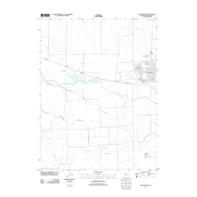
2011 Map of McCook West
USGS Topo · Published 2011About this map
McCook and its surrounding plains are defined by an intricate network of irrigation and water management systems south of the Republican Valley. The Republican River winds through the center of the landscape, flanked by the Meeker Canal and the Culbertson Canal, which represent the vital agricultural infrastructure of Southwest Nebraska. Near the town center, the Red Willow County Fairgrounds and the McCook Post Office serve as focal points for the community, while the Calvary Cemetery and Memorial Park Cemetery provide significant records for local genealogical research.
Find a feature on this map
30 named features on this map. Tap any name to fly to it.
Don’t see what you’re looking for? This feature index may not catch every label — zoom into the map to look around manually.
Map Details
Editions of this 2011 McCook West Map
This is the sole edition of this map. No revisions or reprints were ever made.
Other maps of this area

1954 · McCook
USGS Topo · 1:250,000

1957 · McCook
USGS Topo · 1:250,000

1957 · McCook SW
USGS Topo · 1:24,000

1957 · McCook SE
USGS Topo · 1:24,000

1958 · McCook
USGS Topo · 1:250,000

1970 · Red Willow Dam
USGS Topo · 1:24,000
1970 · Culbertson
USGS Topo · 1:24,000

1970 · McCook West
USGS Topo · 1:24,000

1970 · Burger Canyon SE
USGS Topo · 1:24,000

1970 · Quick SE
USGS Topo · 1:24,000