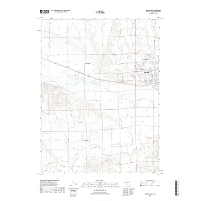
2017 Map of McCook West
USGS Topo · Published 2017About this map
The city of McCook serves as the focal point of this western Nebraska landscape, where the residential street grid gives way to the irrigation networks of the Republican River valley. This 2017 survey details the complex water management system of the High Plains, including the Meeker Canal, Driftwood Canal, and Driftwood W Canal, which are essential to the region's agricultural productivity. On the western edge of the city, the Memorial Park Cem and Calvary Cem provide significant landmarks for local history and genealogy. Beyond the urban limits, the map traces the convergence of multiple seasonal drainages like Dry Cr and Driftwood Cr, alongside modern developments such as Blue Jay Trl and Finch Trl. The inclusion of the settlement at Perry illustrates the dispersed nature of rail-and-river communities along the primary transit corridors of Red Willow County.
Find a feature on this map
54 named features on this map. Tap any name to fly to it.
Don’t see what you’re looking for? This feature index may not catch every label — zoom into the map to look around manually.
Map Details
Editions of this 2017 McCook West Map
This is the sole edition of this map. No revisions or reprints were ever made.
Other maps of this area

1954 · McCook
USGS Topo · 1:250,000

1957 · McCook
USGS Topo · 1:250,000

1957 · McCook SW
USGS Topo · 1:24,000

1957 · McCook SE
USGS Topo · 1:24,000

1958 · McCook
USGS Topo · 1:250,000

1970 · Red Willow Dam
USGS Topo · 1:24,000
1970 · Culbertson
USGS Topo · 1:24,000

1970 · McCook West
USGS Topo · 1:24,000

1970 · Burger Canyon SE
USGS Topo · 1:24,000

1970 · Quick SE
USGS Topo · 1:24,000