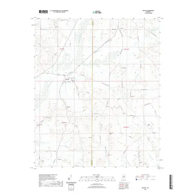
2020 Map of McCool
USGS Topo · Published 2020About this map
McCool serves as the central hub of this landscape, situated along the Yockanookany River at the intersection of several local routes like Smythe St and Bowie St. The map reveals a high density of rural burial sites, including the Mount Pilgrim Cem, McCool Cem, and Bowie Chapel Cem, which reflect the generations of families settled across the Attala and Choctaw county line. To the south and east, the terrain rises into the Ironstone Hills, where smaller communities like Kerr are found among a network of creeks including Wildcat Cr and Hurricane Cr. The geography is defined by its water sources, from the steady flow of Tibby Cr to the localized Lignite Spring, illustrating a late-20th-century rural Mississippi landscape where timber and small-scale agriculture dictate the settlement patterns.
Find a feature on this map
76 named features on this map. Tap any name to fly to it.
Don’t see what you’re looking for? This feature index may not catch every label — zoom into the map to look around manually.
Map Details
Editions of this 2020 McCool Map
This is the sole edition of this map. No revisions or reprints were ever made.
Other maps of this area

1953 · West Point
USGS Topo · 1:250,000

1958 · West Point
USGS Topo · 1:250,000

1963 · West Point
USGS Topo · 1:250,000

1966 · Weir
USGS Topo · 1:24,000

1966 · French Camp
USGS Topo · 1:24,000

1968 · Weir
USGS Topo · 1:62,500

1972 · McCool
USGS Topo · 1:24,000

1972 · Highpoint
USGS Topo · 1:24,000
1972 · Ethel North
USGS Topo · 1:24,000
1972 · Ethel SE
USGS Topo · 1:24,000