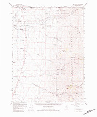
1959 Map of McDermitt
USGS Topo · Published 1984About this map
McDermitt sits at the northern edge of this high-desert landscape where the Quinn River crosses the border from Oregon into Nevada. The map highlights the extensive Fort Mc Dermitt Indian Reservation, reflecting a history of ranching and administrative centers like the Fort Mc Dermitt Ranch Hdqrs. and family-named operations such as Minor Ranch and Giacometto Ranch. To the south and east, the terrain rises sharply into the Santa Rosa Mountains within the Humboldt National Forest. This mountainous region is marked by a legacy of early 20th-century prospecting, shown through numerous claims such as the National Mine, Auto Mine, and the Cordero Mine. Geologists and historians can trace the network of drainage systems from Eightmile Creek to the North Fork Little Humboldt River, alongside landmarks like Buckskin Mtn and McConnell Peak.
Find a feature on this map
65 named features on this map. Tap any name to fly to it.
Don’t see what you’re looking for? This feature index may not catch every label — zoom into the map to look around manually.
Map Details
Editions of this 1959 McDermitt Map
3 editions found
Other maps of this area

1882 · Paradise
USGS Topo · 1:250,000

1893 · Paradise
USGS Topo · 1:250,000

1955 · McDermitt
USGS Topo · 1:250,000

1955 · Jordan Valley
USGS Topo · 1:250,000

1957 · Jordan Valley
USGS Topo · 1:250,000

1958 · Jordan Valley
USGS Topo · 1:250,000

1959 · McDermitt
USGS Topo · 1:250,000

1959 · Orovada
USGS Topo · 1:62,500

1959 · McDermitt
USGS Topo · 1:62,500

1959 · Hinkey Summit
USGS Topo · 1:62,500