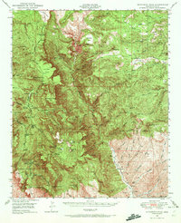
1949 Map of McFadden Peak
USGS Topo · Published 1972About this map
Tonto National Forest land defines the rugged topography of Gila County in this mid-century survey, where deep canyons and high peaks dictate the layout of human activity. The map captures the remote operations of the Pueblo Mine and Lucky Strike Mine, alongside a network of isolated homesteads and grazing sites like Peterson Ranch and Cook Ranch. Resource management and fire suppression are evident through the McFadden Pk Lookout and the Reynolds Cr Ranger Sta, while specialized land use is marked by the Sierra Ancha Experimental Forest and its Parker Creek Experiment Sta. The complex hydrology of the region is traced through features such as Workman Creek Falls and the winding Cherry Creek corridor. This era of the landscape shows a territory balanced between wild forest terrain and a scattered ranching and mining economy.
Find a feature on this map
90 named features on this map. Tap any name to fly to it.
Don’t see what you’re looking for? This feature index may not catch every label — zoom into the map to look around manually.
Map Details
Editions of this 1949 McFadden Peak Map
3 editions found

Other maps of this area

1886 · Holbrook
USGS Topo · 1:250,000

1887 · Verde
USGS Topo · 1:250,000

1892 · Verde
USGS Topo · 1:250,000

1893 · Holbrook
USGS Topo · 1:250,000

1907 · Roosevelt
USGS Topo · 1:125,000

1909 · Four Peaks
USGS Topo · 1:125,000

1912 · Roosevelt
USGS Topo · 1:125,000

1922 · Chrysotile
USGS Topo · 1:125,000

1937 · Diamond Butte
USGS Topo · 1:48,000

1943 · Diamond Butte
USGS Topo · 1:62,500