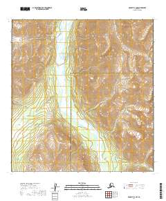
2019 Map of McGrath A-1 NW
USGS Topo · Published 2019About this map
The South Fork Kuskokwim River defines the central corridor of this Alaskan wilderness, winding through a high-elevation landscape where the Yukon-Koyukuk and Bethel Census Area boundaries meet. The terrain is marked by significant vertical relief, rising from the braided river valley to prominent heights such as Knox Peak. Steep geographical features like Graptolite Canyon and Barren Rid indicate a landscape shaped by significant erosion and geological force, while several smaller drainages including Wolverine Cr and Brush Cr feed into the primary river system. This survey illustrates the intricate tributary network of the Kuskokwim watershed in a region characterized by its lack of road infrastructure, where the primary movement and geography follow natural watercourses and mountain ridgelines.
Find a feature on this map
14 named features on this map. Tap any name to fly to it.
Don’t see what you’re looking for? This feature index may not catch every label — zoom into the map to look around manually.
Map Details
Editions of this 2019 McGrath A-1 NW Map
This is the sole edition of this map. No revisions or reprints were ever made.
Other maps of this area

1949 · McGrath
USGS Topo · 1:250,000

1950 · McGrath
USGS Topo · 1:250,000

1958 · McGrath B-1
USGS Topo · 1:63,360

1958 · McGrath A-2
USGS Topo · 1:63,360

1958 · McGrath A-1
USGS Topo · 1:63,360

1958 · McGrath B-2
USGS Topo · 1:63,360

1958 · McGrath
USGS Topo · 1:250,000
2017 · McGrath A-1 SE
USGS Topo · 1:25,000
2019 · McGrath A-2 SE
USGS Topo · 1:25,000
2019 · McGrath B-1 SW
USGS Topo · 1:25,000