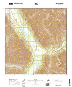
2019 Map of McGrath B-1 SW
USGS Topo · Published 2019About this map
The South Fork Kuskokwim River carves through this portion of the interior, meeting the Tatina River amidst the high-elevation terrain of the Alaska Range. The landscape is dominated by the massive formations of the Teocalli Mountains to the north and the Terra Cotta Mountains to the southwest, creating a corridor of drainage for glacial tributaries including Lynx Cr and Dalzell Cr. This remote area, mapped in the early twenty-first century, represents a critical intersection of river valleys and mountain passes. The presence of the Tatitna Airport near the confluence of the major rivers highlights the reliance on air travel for access in a region devoid of established road networks, serving as a vital link for the Yukon-Koyukuk Census Area.
Find a feature on this map
15 named features on this map. Tap any name to fly to it.
Don’t see what you’re looking for? This feature index may not catch every label — zoom into the map to look around manually.
Map Details
Editions of this 2019 McGrath B-1 SW Map
This is the sole edition of this map. No revisions or reprints were ever made.
Other maps of this area

1949 · McGrath
USGS Topo · 1:250,000

1950 · McGrath
USGS Topo · 1:250,000

1958 · McGrath B-1
USGS Topo · 1:63,360

1958 · McGrath A-2
USGS Topo · 1:63,360

1958 · McGrath A-1
USGS Topo · 1:63,360

1958 · McGrath B-2
USGS Topo · 1:63,360

1958 · McGrath
USGS Topo · 1:250,000
2017 · McGrath B-1 NE
USGS Topo · 1:25,000
2019 · McGrath A-1 NE
USGS Topo · 1:25,000
2019 · McGrath A-2 NE
USGS Topo · 1:25,000