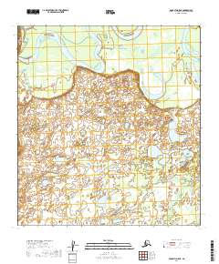
2019 Map of McGrath D-5 NE
USGS Topo · Published 2019About this map
Kuskokwim River dominates the northern reaches of this interior landscape, weaving a complex network of active channels and seasonal sloughs through the low-lying terrain. The river's movement over time is etched into the earth, visible in the intricate pattern of oxbow lakes and wetlands that stretch south toward Blackwater Cr. This 2019 survey documents the subtle transitions of the Gnejilina Creek confluence, illustrating a watershed where water and land are in constant, slow-motion negotiation. The absence of roads or permanent structures on this sheet underscores the preservation of a traditional Alaskan riverine environment, where the shifting hydrology remains the primary architect of the geography.
Find a feature on this map
9 named features on this map. Tap any name to fly to it.
Don’t see what you’re looking for? This feature index may not catch every label — zoom into the map to look around manually.
Map Details
Editions of this 2019 McGrath D-5 NE Map
This is the sole edition of this map. No revisions or reprints were ever made.
Other maps of this area

1949 · McGrath
USGS Topo · 1:250,000

1950 · Medfra
USGS Topo · 1:250,000

1950 · McGrath
USGS Topo · 1:250,000

1953 · McGrath D-5
USGS Topo · 1:63,360

1953 · McGrath D-4
USGS Topo · 1:63,360

1954 · Medfra A-5
USGS Topo · 1:63,360

1958 · McGrath
USGS Topo · 1:250,000
1959 · Medfra A-4
USGS Topo · 1:63,360

1959 · Medfra
USGS Topo · 1:250,000
2019 · McGrath D-5 NW
USGS Topo · 1:25,000