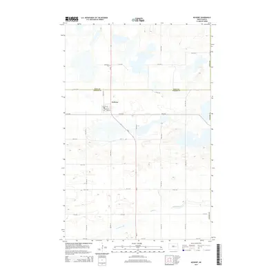
2014 Map of McHenry
USGS Topo · Published 2014About this map
McHenry anchors this prairie landscape in eastern North Dakota, situated just south of the Eddy Co and Foster Co line. The town's grid is clearly defined by local thoroughfares including Chadwick Ave, Hurd Ave, and Jones Ave, while ND-20 serves as the primary regional artery cutting diagonally across the township. This 2014 survey reveals a transition from the agricultural uplands down toward the meandering path of Baldhill Creek in the south, illustrating the drainage patterns vital to the region's farming heritage. North of the town center, Bethlehem Cem stands as a significant landmark for those tracing family history and local ancestry. The map provides a precise view of the rural section-line road network, such as 13th St NE and 92nd Ave NE, which has structured the prairie into its modern agricultural layout.
Find a feature on this map
26 named features on this map. Tap any name to fly to it.
Don’t see what you’re looking for? This feature index may not catch every label — zoom into the map to look around manually.
Map Details
Editions of this 2014 McHenry Map
This is the sole edition of this map. No revisions or reprints were ever made.
Other maps of this area
1900 · Pingree
USGS Topo · 1:125,000
1951 · Kensal NW
USGS Topo · 1:24,000
1951 · Glenfield
USGS Topo · 1:24,000
1952 · New Rockford
USGS Topo · 1:250,000
1956 · New Rockford
USGS Topo · 1:250,000
1961 · Lake Coe
USGS Topo · 1:24,000
1961 · McHenry
USGS Topo · 1:24,000
1961 · Juanita
USGS Topo · 1:24,000
1961 · Sutton
USGS Topo · 1:24,000
1961 · Johnson Lake
USGS Topo · 1:24,000