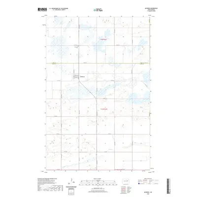
2020 Map of McHenry
USGS Topo · Published 2020About this map
McHenry sits at the intersection of local routes in the heart of this North Dakota landscape, straddling the line between t148n r62w and t147n r62w. The settlement is defined by a grid of streets including Chadwick Ave and Jones Ave, surrounded by numerous small prairie wetlands. To the north, the Bethlehem Cem serves as a significant genealogical marker for local families. The southern portion of the quadrangle is dominated by the winding path of Baldhill Creek, also labeled in sections as Baldhill Cr, which carves through the township as it flows toward the eastern border of Foster County. This survey illustrates the persistent section-line road network characteristic of the region, with routes like 12th St NE and 11th St NE providing the primary structure for travel through the agricultural surroundings.
Find a feature on this map
18 named features on this map. Tap any name to fly to it.
Don’t see what you’re looking for? This feature index may not catch every label — zoom into the map to look around manually.
Map Details
Editions of this 2020 McHenry Map
This is the sole edition of this map. No revisions or reprints were ever made.
Other maps of this area

1900 · Pingree
USGS Topo · 1:125,000

1951 · Kensal NW
USGS Topo · 1:24,000

1951 · Glenfield
USGS Topo · 1:24,000

1952 · New Rockford
USGS Topo · 1:250,000

1956 · New Rockford
USGS Topo · 1:250,000
1961 · Lake Coe
USGS Topo · 1:24,000

1961 · McHenry
USGS Topo · 1:24,000
1961 · Juanita
USGS Topo · 1:24,000

1961 · Sutton
USGS Topo · 1:24,000

1961 · Johnson Lake
USGS Topo · 1:24,000