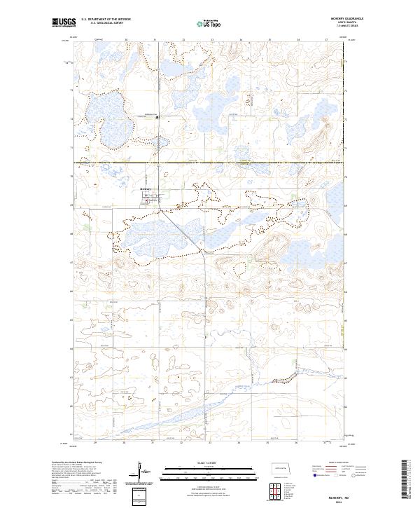
2024 Map of McHenry
USGS Topo · Published 2024About this map
McHenry sits at the heart of this landscape where the borders of Foster, Eddy, and Griggs counties meet. The town's grid is clearly defined by streets such as Johnston St, Hurd Ave, and Ward Ave, providing a detailed look at the local settlement pattern. To the north, Bethlehem Cem serves as a significant landmark for those researching family history in the area. The surrounding terrain is characterized by a high concentration of wetlands and conservation lands, including the Eddy County Waterfowl Production Area and the Foster County Waterfowl Production Area. Baldhill Creek winds through the southern portion of the quadrangle, illustrating the natural drainage and prairie potholes that define this region of North Dakota.
Find a feature on this map
31 named features on this map. Tap any name to fly to it.
Don’t see what you’re looking for? This feature index may not catch every label — zoom into the map to look around manually.
Map Details
Editions of this 2024 McHenry Map
This is the sole edition of this map. No revisions or reprints were ever made.
Other maps of this area

1900 · Pingree
USGS Topo · 1:125,000

1951 · Kensal NW
USGS Topo · 1:24,000

1951 · Glenfield
USGS Topo · 1:24,000

1952 · New Rockford
USGS Topo · 1:250,000

1956 · New Rockford
USGS Topo · 1:250,000
1961 · Lake Coe
USGS Topo · 1:24,000

1961 · McHenry
USGS Topo · 1:24,000
1961 · Juanita
USGS Topo · 1:24,000

1961 · Sutton
USGS Topo · 1:24,000

1961 · Johnson Lake
USGS Topo · 1:24,000