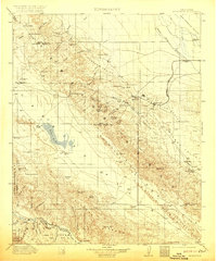
1912 Map of McKittrick
USGS Topo · Published 1920About this map
McKittrick and the surrounding McKittrick Valley define this transition from the oil-rich slopes of the Temblor Range to the wide expanse of the San Joaquin Valley. In the early twentieth century, the industrial footprint of the region was already established, with a prominent Pipe Line and the Southern Pacific RR serving the burgeoning settlements at Fellows, Reward, and Midland PO. To the west, the landscape shifts dramatically toward the alkaline basin of Soda Lake and the Panorama Hills. This geography is dotted with remote outposts and family holdings like McAlesters Ranch and Joe Santos Ranch, while landmarks such as Painted Rock hint at the area's ancient human history. The map also records essential water sources for the era's ranching and industry, including Thompson Spring and Sulphur Spring.
Find a feature on this map
81 named features on this map. Tap any name to fly to it.
Don’t see what you’re looking for? This feature index may not catch every label — zoom into the map to look around manually.
Map Details
Editions of this 1912 McKittrick Map
4 editions found
Other maps of this area

1902 · Santa Ynez
USGS Topo · 1:125,000

1903 · Mt. Pinos
USGS Topo · 1:125,000

1905 · Santa Ynez
USGS Topo · 1:125,000

1905 · Lompoc
USGS Topo · 1:125,000

1910 · Buena Vista Lake
USGS Topo · 1:125,000

1912 · McKittrick
USGS Topo · 1:125,000

1912 · Buena Vista Lake
USGS Topo · 1:125,000

1914 · Lost Hills
USGS Topo · 1:125,000

1914 · Cholame
USGS Topo · 1:125,000

1915 · Cholame
USGS Topo · 1:125,000