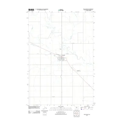
2012 Map of McLaughlin
USGS Topo · Published 2012About this map
The town of McLaughlin serves as a central hub in Corson County, established along a grid system defined by streets like Railway St and numbered avenues including 3rd Ave E. The surrounding landscape is dominated by the winding path of Oak Cr, which meanders extensively through the prairie terrain north and east of the main settlement. This 2012 survey illustrates the connectivity of the region through a network of rural routes such as Kenel Rd, Bullhead Rd, and Oak Creek Rd, which link the town to the broader Standing Rock Reservation area. Local infrastructure is anchored by the Mc Laughlin Municipal Airport to the southeast and the Protestant Cem located just north of the residential center, providing essential geographic markers for genealogists and local historians tracking the community's footprint in the early 21st century.
Find a feature on this map
18 named features on this map. Tap any name to fly to it.
Don’t see what you’re looking for? This feature index may not catch every label — zoom into the map to look around manually.
Map Details
Editions of this 2012 McLaughlin Map
This is the sole edition of this map. No revisions or reprints were ever made.
Other maps of this area
1953 · McIntosh
USGS Topo · 1:250,000
1956 · Wakpala NW
USGS Topo · 1:24,000
1956 · Little Eagle
USGS Topo · 1:24,000
1956 · Little Eagle NW
USGS Topo · 1:24,000
1958 · McIntosh
USGS Topo · 1:250,000
1966 · McLaughlin
USGS Topo · 1:24,000
1966 · McLaughlin NE
USGS Topo · 1:24,000
1966 · Mahto
USGS Topo · 1:24,000
1966 · Mahto NW
USGS Topo · 1:24,000
1971 · McLaughlin SW
USGS Topo · 1:24,000