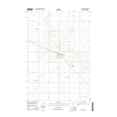
2015 Map of McLaughlin
USGS Topo · Published 2015About this map
The town of McLaughlin serves as the central hub of this prairie landscape, where the local street grid intersects with significant regional thoroughfares. The town layout is clearly defined by named streets such as Cedar Ave and Elevator Rd, indicating its role as a point of commerce and transit. To the northwest, the Protestant Cem is a notable landmark for genealogical research, while the Mc Laughlin Municipal Airport to the southeast reflects the area's modern infrastructure. The winding course of Oak Cr cuts through the northern sections, including Township 22 North, Range 27 East, providing a natural contrast to the rigid, mile-spaced section line roads like 106th St and 267th Ave that define the agricultural parcels of Corson County.
Find a feature on this map
33 named features on this map. Tap any name to fly to it.
Don’t see what you’re looking for? This feature index may not catch every label — zoom into the map to look around manually.
Map Details
Editions of this 2015 McLaughlin Map
This is the sole edition of this map. No revisions or reprints were ever made.
Other maps of this area
1953 · McIntosh
USGS Topo · 1:250,000
1956 · Wakpala NW
USGS Topo · 1:24,000
1956 · Little Eagle
USGS Topo · 1:24,000
1956 · Little Eagle NW
USGS Topo · 1:24,000
1958 · McIntosh
USGS Topo · 1:250,000
1966 · McLaughlin
USGS Topo · 1:24,000
1966 · McLaughlin NE
USGS Topo · 1:24,000
1966 · Mahto
USGS Topo · 1:24,000
1966 · Mahto NW
USGS Topo · 1:24,000
1971 · McLaughlin SW
USGS Topo · 1:24,000