
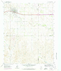
1963 Map of McLean
USGS Topo · Published 1967About this map
The city of McLean is the primary focus of this early 1960s survey, showing the community as it functioned along the path of the Chicago Rock Island and Pacific railroad. The map records a transition in the local landscape where urban recreation and industry met the surrounding ranch land. Prominent features include the Hillcrest Cem on the town's western edge, alongside localized landmarks like the Rodeo Ground, Golf Course, and a Drive-in Theater.
Find a feature on this map
21 named features on this map. Tap any name to fly to it.
Don’t see what you’re looking for? This feature index may not catch every label — zoom into the map to look around manually.
Map Details
Editions of this 1963 McLean Map
2 editions found
Other maps of this area

1954 · Amarillo
USGS Topo · 1:250,000

1958 · Amarillo
USGS Topo · 1:250,000

1959 · Troublesome Creek
USGS Topo · 1:24,000

1959 · Spencer Lake
USGS Topo · 1:24,000

1962 · Hudgens Ranch
USGS Topo · 1:24,000

1962 · Back
USGS Topo · 1:24,000

1962 · Pakan
USGS Topo · 1:24,000

1963 · Alanreed
USGS Topo · 1:24,000

1963 · Ramsdell
USGS Topo · 1:24,000
1964 · Abra
USGS Topo · 1:24,000