
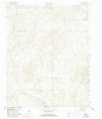
1962 Map of Pakan
USGS Topo · Published 1965About this map
The Oil and Gas Field dominates this Panhandle landscape in the early 1960s, defined by a dense grid of Oil Wells and Gas Wells that stretch across the rolling terrain. The map records the infrastructure of the mid-century energy boom, including a network of pipelines and multiple pumping stations that connected this remote portion of Wheeler County to larger regional markets. Small settlements like Kellerville and Magic City sit at the edges of the survey, while the namesake community of Pakan serves as a central point, anchored by the Pakan Cem.
Find a feature on this map
16 named features on this map. Tap any name to fly to it.
Don’t see what you’re looking for? This feature index may not catch every label — zoom into the map to look around manually.
Map Details
Editions of this 1962 Pakan Map
2 editions found
Other maps of this area

1954 · Amarillo
USGS Topo · 1:250,000

1958 · Amarillo
USGS Topo · 1:250,000

1962 · Back
USGS Topo · 1:24,000

1962 · Pond Creek
USGS Topo · 1:24,000

1962 · Wheeler
USGS Topo · 1:24,000

1962 · Spring Creek
USGS Topo · 1:24,000

1962 · Wheeler SE
USGS Topo · 1:24,000

1963 · Ramsdell
USGS Topo · 1:24,000

1963 · Shamrock West
USGS Topo · 1:24,000

1963 · McLean
USGS Topo · 1:24,000