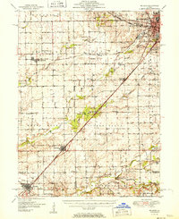
1951 Map of McLean
USGS Topo · Published 1951About this map
The agricultural heart of Illinois in the early 1950s is defined by a dense network of country schools and rural churches centered around Bloomington. This area shows the transition from local steam-and-rail dominance to modern infrastructure, where the Gulf Mobile and Ohio and Pennsylvania railroads intersect with the Illinois Terminal electric line. These rail corridors supported small grain-handling points and livestock hubs like Stanford, Shirley, and McLean.
Find a feature on this map
64 named features on this map. Tap any name to fly to it.
Don’t see what you’re looking for? This feature index may not catch every label — zoom into the map to look around manually.
Map Details
Editions of this 1951 McLean Map
2 editions found
Other maps of this area

1911 · Lincoln
USGS Topo · 1:62,500

1913 · Lincoln
USGS Topo · 1:62,500

1926 · Normal
USGS Topo · 1:62,500

1927 · Danvers
USGS Topo · 1:62,500

1928 · Mackinaw
USGS Topo · 1:62,500

1930 · Danvers
USGS Topo · 1:62,500

1930 · Normal
USGS Topo · 1:62,500

1932 · Mackinaw
USGS Topo · 1:62,500

1949 · Mc Lean
USGS Topo · 1:62,500

1951 · McLean
USGS Topo · 1:62,500