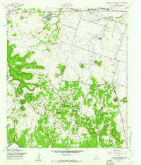
1958 Map of McMillan Mountains
USGS Topo · Published 1961About this map
The Fort Hood Military Reservation Bdy dominates this mid-century landscape on the border of Coryell and Bell counties. The transition from rural homesteading to military utility is evident, with the Emergency Landing Strip and various training grounds encroaching upon the rugged terrain of the McMillan Mountains and Sevenmile Mountain. Genealogy researchers will find significant interest in the scattered burial sites preserved within or near the reservation boundary, including Brown Cem and Mayberry Cem, as well as Calvary Ch to the southeast.
Find a feature on this map
27 named features on this map. Tap any name to fly to it.
Don’t see what you’re looking for? This feature index may not catch every label — zoom into the map to look around manually.
Map Details
Editions of this 1958 McMillan Mountains Map
3 editions found
Other maps of this area

1893 · Georgetown
USGS Topo · 1:125,000

1894 · Gatesville
USGS Topo · 1:125,000

1930 · Killeen
USGS Topo · 1:62,500

1947 · Fort Hood
USGS Topo · 1:62,500

1947 · Fort Hood
USGS Topo · 1:24,000

1947 · Post Oak Mountain
USGS Topo · 1:24,000

1947 · Killeen
USGS Topo · 1:62,500

1947 · McMillan Mountains
USGS Topo · 1:24,000

1947 · Killeen
USGS Topo · 1:24,000

1947 · Twin Moutains
USGS Topo · 1:24,000