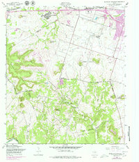
1958 Map of McMillan Mountains
USGS Topo · Published 1979About this map
Fort Hood Military Reservation dominates this central Texas landscape, where the sprawling military presence meets the growing urban fringes of Killeen and Copperas Cove. The map documents a period of rapid development and military utility, centered on Gray Army Airfield and the tactical terrain of the McMillan Mountains. Local life is recorded in residential pockets like Kay Bee Heights and the Willow Springs Community Center, while the culture of the era is marked by the presence of a Drive-in Theater on the outskirts of town.
Find a feature on this map
34 named features on this map. Tap any name to fly to it.
Don’t see what you’re looking for? This feature index may not catch every label — zoom into the map to look around manually.
Map Details
Editions of this 1958 McMillan Mountains Map
3 editions found
Other maps of this area

1893 · Georgetown
USGS Topo · 1:125,000

1894 · Gatesville
USGS Topo · 1:125,000

1930 · Killeen
USGS Topo · 1:62,500

1947 · Fort Hood
USGS Topo · 1:62,500

1947 · Fort Hood
USGS Topo · 1:24,000

1947 · Post Oak Mountain
USGS Topo · 1:24,000

1947 · Killeen
USGS Topo · 1:62,500

1947 · McMillan Mountains
USGS Topo · 1:24,000

1947 · Killeen
USGS Topo · 1:24,000

1947 · Twin Moutains
USGS Topo · 1:24,000