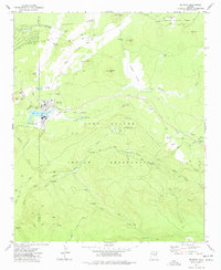
1977 Map of McNary
USGS Topo · Published 1978About this map
McNary sits at the northern edge of the Fort Apache Indian Reservation, serving as a focal point for settlement and industry on the Mogollon Rim. The landscape is defined by the transition from the high-elevation Sitgreaves National Forest down toward the winding drainage of the North Fork White River. This era of the late 1970s shows the infrastructure of a working timber and resource landscape, evidenced by the extensive Old Railroad Grade and numerous log roads like the Upper Log Road. Grounded details for local researchers include the Williams Creek National Fish Hatchery, the town's Cem, and an Athletic Field. Significant water features like Gooseberry Dam Lake and Cluff Cienega highlight the vital role of water management in this high-country environment shared by Navajo and Apache Counties.
Find a feature on this map
51 named features on this map. Tap any name to fly to it.
Don’t see what you’re looking for? This feature index may not catch every label — zoom into the map to look around manually.
Map Details
Editions of this 1977 McNary Map
3 editions found
Other maps of this area

1886 · St Johns
USGS Topo · 1:250,000

1892 · St Johns
USGS Topo · 1:250,000

1954 · Clifton
USGS Topo · 1:250,000

1954 · Saint Johns
USGS Topo · 1:250,000

1957 · Clifton
USGS Topo · 1:250,000

1957 · Saint Johns
USGS Topo · 1:250,000

1958 · Clifton
USGS Topo · 1:250,000

1958 · Saint Johns
USGS Topo · 1:250,000

1961 · McNary
USGS Topo · 1:62,500

1962 · Clifton
USGS Topo · 1:250,000