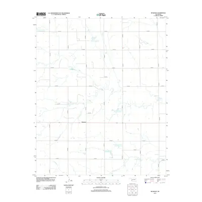
2012 Map of McQueen
USGS Topo · Published 2012About this map
McQueen occupies a central position within this landscape of southwestern Oklahoma, where the town site is surrounded by a dense grid of rural section roads. The terrain is defined by the winding paths of Turkey Cr and Cottonwood Cr, which have been systematically managed through a series of water control structures. This 2012 survey illustrates a sophisticated network of reservoirs, including Tri-County Turkey Cr Site 12 Reservoir and Tri-County Turkey Cr Site 21 Reservoir, reflecting modern land management and irrigation practices in Harmon County. The map provides a precise look at the rural infrastructure of the early 21st century, detailing the numerous county roads like n1840 RD and e1630 RD that connect the isolated homesteads and agricultural plots of this prairie region.
Find a feature on this map
25 named features on this map. Tap any name to fly to it.
Don’t see what you’re looking for? This feature index may not catch every label — zoom into the map to look around manually.
Map Details
Editions of this 2012 McQueen Map
This is the sole edition of this map. No revisions or reprints were ever made.
Other maps of this area

1955 · Lawton
USGS Topo · 1:250,000

1961 · Hollis
USGS Topo · 1:62,500

1971 · Russell
USGS Topo · 1:24,000

1971 · Mangum South
USGS Topo · 1:24,000

1971 · Mc Queen
USGS Topo · 1:24,000

1971 · Duke SW
USGS Topo · 1:24,000

1971 · Duke
USGS Topo · 1:24,000

1971 · Prairie Hill
USGS Topo · 1:24,000
1971 · Shrewder
USGS Topo · 1:24,000

1975 · Hollis NE
USGS Topo · 1:24,000