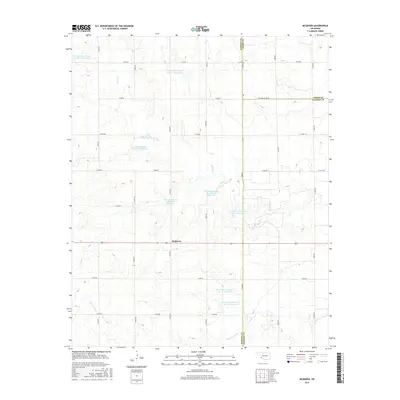
2016 Map of McQueen
USGS Topo · Published 2016About this map
McQueen serves as the primary focal point of this southwestern Oklahoma landscape, positioned along Route 62 near the tri-county juncture of Harmon, Greer, and Jackson counties. The terrain is defined by an extensive water management system designed to harness the seasonal flows of Turkey Creek and Cottonwood Creek. This network includes numerous impoundments such as Tri-County Turkey Cr Site 3 Reservoir, Tri-County Turkey Creek Site 11 Reservoir, and Tri-County Turkey Cr Site 21 Reservoir. The regular grid of section roads, including N1850 Road and E1600 Road, illustrates the agricultural organization of the territory. The presence of these specific reservoirs highlights the critical importance of water conservation and flood control in this prairie environment during the early 21st century.
Find a feature on this map
32 named features on this map. Tap any name to fly to it.
Don’t see what you’re looking for? This feature index may not catch every label — zoom into the map to look around manually.
Map Details
Editions of this 2016 McQueen Map
This is the sole edition of this map. No revisions or reprints were ever made.
Other maps of this area

1955 · Lawton
USGS Topo · 1:250,000

1961 · Hollis
USGS Topo · 1:62,500

1971 · Russell
USGS Topo · 1:24,000

1971 · Mangum South
USGS Topo · 1:24,000

1971 · Mc Queen
USGS Topo · 1:24,000

1971 · Duke SW
USGS Topo · 1:24,000

1971 · Duke
USGS Topo · 1:24,000

1971 · Prairie Hill
USGS Topo · 1:24,000
1971 · Shrewder
USGS Topo · 1:24,000

1975 · Hollis NE
USGS Topo · 1:24,000