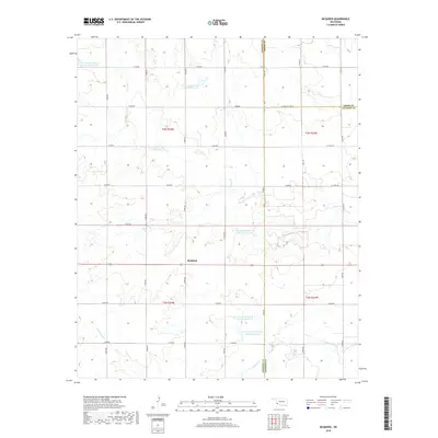
2018 Map of McQueen
USGS Topo · Published 2018About this map
McQueen occupies a central position in this southwestern Oklahoma landscape, situated at the crossroads of several section-line roads in Harmon County. The surrounding terrain is defined by a sophisticated system of water management, evidenced by the numerous reservoirs distributed along the drainages. These include Tri-County Turkey Cr Site 3 Reservoir, Tri-County Turkey Cr Site 7 Reservoir, and Tri-County Turkey Cr Site 12 Reservoir, which serve as critical infrastructure for the agricultural lands of the region. The landscape is carved by the winding paths of Turkey Cr and Cottonwood Cr, which traverse the prairie across township lines. State Highway 62 provides the primary east-west corridor through the area, linking the local farming community to the broader county network near the boundaries of Greer and Jackson Counties.
Find a feature on this map
32 named features on this map. Tap any name to fly to it.
Don’t see what you’re looking for? This feature index may not catch every label — zoom into the map to look around manually.
Map Details
Editions of this 2018 McQueen Map
This is the sole edition of this map. No revisions or reprints were ever made.
Other maps of this area

1955 · Lawton
USGS Topo · 1:250,000

1961 · Hollis
USGS Topo · 1:62,500

1971 · Russell
USGS Topo · 1:24,000

1971 · Mangum South
USGS Topo · 1:24,000

1971 · Mc Queen
USGS Topo · 1:24,000

1971 · Duke SW
USGS Topo · 1:24,000

1971 · Duke
USGS Topo · 1:24,000

1971 · Prairie Hill
USGS Topo · 1:24,000
1971 · Shrewder
USGS Topo · 1:24,000

1975 · Hollis NE
USGS Topo · 1:24,000