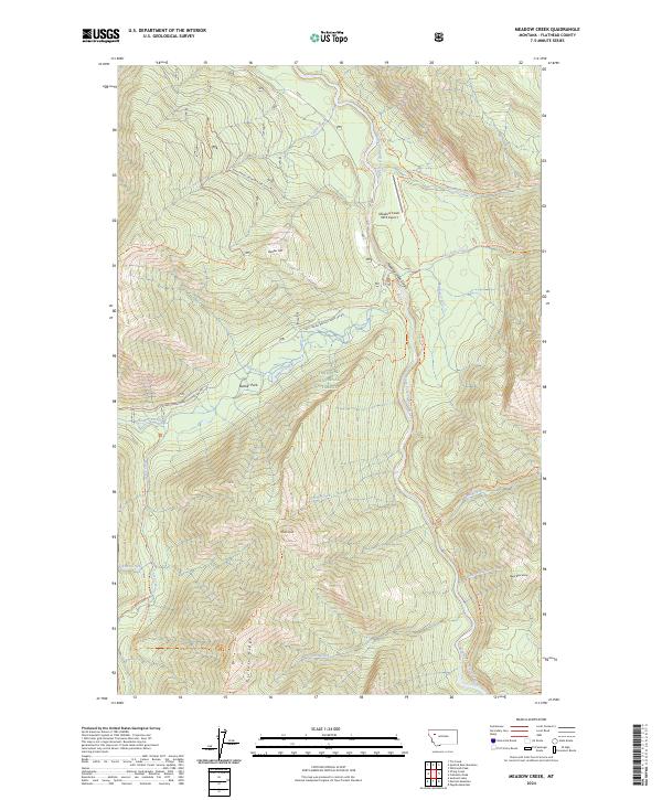
2024 Map of Meadow Creek
USGS Topo · Published 2024About this map
The Main South Fork Flathead River bisects this remote portion of the Flathead National Forest, following a narrow corridor designated as the Flathead Wild and Scenic River. The terrain is characterized by steep ridges and dramatic vertical relief, including the Meadow Creek Gorge and prominent heights such as Chipmunk Peak and Black Bear Hump. Human infrastructure is minimal, centered primarily on the Meadow Creek USFS Airport and a network of forest service roads like Natl Forest Develop Road 549 Rd and Natl Forest Develop Road 10103 Rd. Much of the southern portion of the map is protected within the Bob Marshall Wilderness, where trails such as the Picture Ridge Trl and Gorge Creek Trl provide the only access through the dense topography near Picture Lake and Sarah Peak.
Find a feature on this map
39 named features on this map. Tap any name to fly to it.
Don’t see what you’re looking for? This feature index may not catch every label — zoom into the map to look around manually.
Map Details
Editions of this 2024 Meadow Creek Map
This is the sole edition of this map. No revisions or reprints were ever made.
Other maps of this area

1936 · Silvertip
USGS Topo · 1:96,000

1942 · Silvertip
USGS Topo · 1:125,000

1955 · Choteau
USGS Topo · 1:250,000

1957 · Choteau
USGS Topo · 1:250,000

1958 · Choteau
USGS Topo · 1:250,000

1962 · Choteau
USGS Topo · 1:250,000

1965 · Sunburst Lake
USGS Topo · 1:24,000
1965 · Tin Creek
USGS Topo · 1:24,000
1965 · String Creek
USGS Topo · 1:24,000
1970 · Cathedral Peak
USGS Topo · 1:24,000