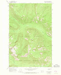
1965 Map of String Creek
USGS Topo · Published 1968About this map
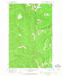
Flathead National Forest and the northern reaches of the Bob Marshall Wilderness dominate this high-country landscape, where the absence of established land lines in the 1960s highlights the region's primitive character. This terrain is defined by a dense network of watercourses and elevation markers, centered around the confluence of Bunker Creek and its many tributaries. Isolated water bodies like Late Lake and Otor Lake are tucked between prominent summits including Tranquil Mountain and Chipmunk Peak. The map provides a detailed view of the early Pack Trail system that served as the primary means of navigation through these drainage basins before modern access. Notable water features like Middle Fork Bunker Creek and Gorge Creek carve through the steep topography, illustrating the natural watershed patterns of Flathead County prior to later development or administrative changes.
Find a feature on this map
25 named features on this map. Tap any name to fly to it.
Don’t see what you’re looking for? This feature index may not catch every label — zoom into the map to look around manually.
Map Details
Editions of this 1965 String Creek Map
2 editions found
Other maps of this area

1936 · Silvertip
USGS Topo · 1:96,000

1942 · Silvertip
USGS Topo · 1:125,000

1955 · Choteau
USGS Topo · 1:250,000

1957 · Choteau
USGS Topo · 1:250,000

1958 · Choteau
USGS Topo · 1:250,000

1962 · Choteau
USGS Topo · 1:250,000
1965 · Connor Creek
USGS Topo · 1:24,000

1965 · Sunburst Lake
USGS Topo · 1:24,000
1965 · Tin Creek
USGS Topo · 1:24,000
1965 · Thunderbolt Mountain
USGS Topo · 1:24,000