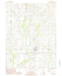
1984 Map of Meadville
USGS Topo · Published 1985About this map
Meadville serves as the primary hub of this north-central Missouri landscape, situated at the junction of several drainage systems and the Burlington Northern railroad. The terrain is defined by the winding course of Parson Creek, which flows south through the center of the sheet, supported by a network of tributaries including Patterson Branch, Coon Creek, and Levee Creek. This 1984 survey highlights a region shaped by agricultural divisions and rural infrastructure, where the Livingston and Linn County line marks a significant political boundary crossing the western portion of the map. Smaller watercourses like Lewis Creek and Hickory Branch further carve the topography, illustrating the intricate watershed patterns that dictate the placement of roads and farmsteads within the townships of Clay, Wheeling, and Parson Creek.
Find a feature on this map
14 named features on this map. Tap any name to fly to it.
Don’t see what you’re looking for? This feature index may not catch every label — zoom into the map to look around manually.
Map Details
Editions of this 1984 Meadville Map
This is the sole edition of this map. No revisions or reprints were ever made.
Other maps of this area

1924 · Chula
USGS Topo · 1:62,500

1924 · Hale
USGS Topo · 1:62,500

1946 · Brookfield
USGS Topo · 1:62,500

1947 · Chula
USGS Topo · 1:62,500

1948 · Brookfield
USGS Topo · 1:62,500

1949 · Sumner
USGS Topo · 1:24,000

1950 · Sumner
USGS Topo · 1:24,000

1951 · Hale
USGS Topo · 1:62,500

1953 · Moberly
USGS Topo · 1:250,000

1954 · Moberly
USGS Topo · 1:250,000