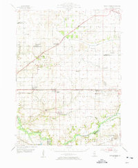
1954 Map of Mechanicsburg
USGS Topo · Published 1955About this map
Mechanicsburg and its surrounding townships define this mid-century landscape east of Springfield, where the transition from prairie to river bottom dictated the location of early settlements. The Sangamon River meanders along the southern edge, flanked by protective embankments like the Spoil Bank and various levee structures, while the Wabash and Illinois Central railroads provided critical links for the region's agricultural economy. This 1954 data reveals a rural community in transition, noting many older institutions like the North Side Sch and the Ray Sch as already abandoned.
Find a feature on this map
76 named features on this map. Tap any name to fly to it.
Don’t see what you’re looking for? This feature index may not catch every label — zoom into the map to look around manually.
Map Details
Editions of this 1954 Mechanicsburg Map
2 editions found

Other maps of this area

1907 · Springfield
USGS Topo · 1:62,500

1911 · Lincoln
USGS Topo · 1:62,500

1913 · Lincoln
USGS Topo · 1:62,500

1922 · Divernon
USGS Topo · 1:62,500

1923 · Taylorville
USGS Topo · 1:62,500

1924 · Divernon
USGS Topo · 1:62,500

1925 · Taylorville
USGS Topo · 1:62,500

1930 · Springfield
USGS Topo · 1:62,500

1940 · Springfield
USGS Topo · 1:62,500

1948 · Mason City
USGS Topo · 1:62,500