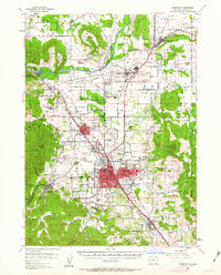
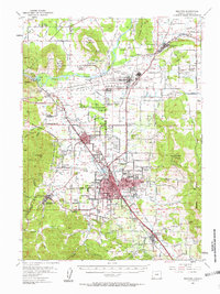
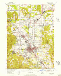
1954 Map of Medford
USGS Topo · Published 1963About this map
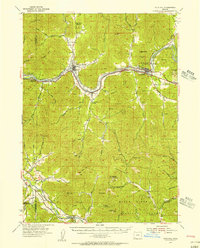
The Rogue River dominates the northern landscape of this mid-century survey, flanked by the distinctive flat-topped silhouettes of Table Rock and Lower Table Rock. During this era, the valley shows a transition from rural homesteading to post-war industrial and military expansion, centered around Medford and Central Point. Evidence of this growth appears in the sprawling White City and the Veterans Hosp, which occupy former military land. The map captures a high density of educational and religious history, marking several Table Rock School (Abandoned) and Antelope School (Aban'd) sites alongside the Rogue River Academy. Transportation is anchored by the Southern Pacific Railroad and the Pacific Highway, which parallel Bear Creek as it flows toward its confluence with the Rogue near Tou Velle State Park. Local aviation and communication are well-represented by the Medford Airport and several radio facilities like Radio Sta (KMED).
Find a feature on this map
85 named features on this map. Tap any name to fly to it.
Don’t see what you’re looking for? This feature index may not catch every label — zoom into the map to look around manually.
Map Details
Editions of this 1954 Medford Map
3 editions found
Other maps of this area

1891 · Ashland
USGS Topo · 1:250,000

1893 · Ashland
USGS Topo · 1:250,000

1897 · Ashland
USGS Topo · 1:250,000

1904 · Riddle
USGS Topo · 1:125,000

1908 · Grants Pass
USGS Topo · 1:125,000

1938 · Medford
USGS Topo · 1:125,000
1943 · Trail
USGS Topo · 1:62,500
1954 · Medford
USGS Topo · 1:62,500
1954 · Butte Falls
USGS Topo · 1:62,500
1954 · Gold Hill
USGS Topo · 1:62,500