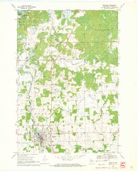
1969 Map of Medford
USGS Topo · Published 1972About this map
Whittlesey sits as a primary rail settlement along the Soo Line in this 1960s study of Taylor County. The landscape is defined by the winding course of the Black River and the West Branch, with the southern portion of the map anchored by the growing city of Medford. Cultural markers of the era are abundant, from the U of Wis (Medford Campus) to the local Fairground and Golf Course.
Find a feature on this map
34 named features on this map. Tap any name to fly to it.
Don’t see what you’re looking for? This feature index may not catch every label — zoom into the map to look around manually.
Map Details
Editions of this 1969 Medford Map
This is the sole edition of this map. No revisions or reprints were ever made.
Other maps of this area

1902 · Marathon
USGS Topo · 1:125,000

1944 · Ogema
USGS Topo · 1:48,000

1945 · Rib Lake
USGS Topo · 1:48,000

1947 · Rib Lake
USGS Topo · 1:48,000

1947 · Ogema
USGS Topo · 1:48,000

1949 · Ogema
USGS Topo · 1:48,000

1949 · Rib Lake
USGS Topo · 1:48,000

1951 · Athens
USGS Topo · 1:48,000

1951 · Medford
USGS Topo · 1:48,000

1953 · Rice Lake
USGS Topo · 1:250,000