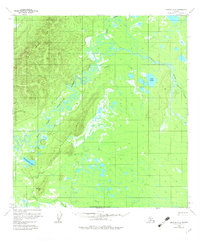
1958 Map of Medfra A-2
USGS Topo · Published 1982About this map
Babybasket Hill rises above the meandering convergence of the East Fork Kuskokwim River and its varied tributaries, documenting a landscape defined by water and isolation in the late 1950s. The map captures a complex drainage system where the Slow Fork Kuskokwim River and Tonzona River wind through expansive wetlands and muskeg. Evidence of human presence is sparse and seasonal, centered on a lone Landing Strip and a network including a Winter Trail and a standard Trail.
Find a feature on this map
20 named features on this map. Tap any name to fly to it.
Don’t see what you’re looking for? This feature index may not catch every label — zoom into the map to look around manually.
Map Details
Editions of this 1958 Medfra A-2 Map
3 editions found
Other maps of this area

1949 · McGrath
USGS Topo · 1:250,000

1950 · Medfra
USGS Topo · 1:250,000

1950 · McGrath
USGS Topo · 1:250,000

1954 · McGrath D-3
USGS Topo · 1:63,360

1954 · Medfra A-3
USGS Topo · 1:63,360

1955 · Medfra B-3
USGS Topo · 1:63,360

1958 · McGrath D-2
USGS Topo · 1:63,360

1958 · Medfra A-2
USGS Topo · 1:63,360

1958 · Medfra B-2
USGS Topo · 1:63,360

1958 · Medfra A-1
USGS Topo · 1:63,360