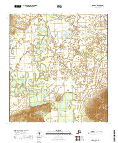
2019 Map of Medfra A-6 SE
USGS Topo · Published 2019About this map
The Takotna River meanders through this interior Alaska landscape, creating a complex network of oxbows and wetlands in the southwestern corner of the Medfra quadrangle. The river’s winding course is mirrored by the Nixon Fork, which snakes southward through the center of the sheet, eventually approaching the larger river. To the northeast, the terrain is defined by the drainage of Broken Snowshoe Cr and the presence of Hook Lake. This area is characterized by low-lying, water-dominant terrain, with the only significant elevation rising in the southeast at Appel Mtn. The lack of named settlements or roads underscores the wilderness character of the Yukon-Koyukuk region, where the hydrology of the Kuskokwim River basin remains the primary geographic feature.
Find a feature on this map
14 named features on this map. Tap any name to fly to it.
Don’t see what you’re looking for? This feature index may not catch every label — zoom into the map to look around manually.
Map Details
Editions of this 2019 Medfra A-6 SE Map
This is the sole edition of this map. No revisions or reprints were ever made.
Other maps of this area

1949 · McGrath
USGS Topo · 1:250,000

1950 · Medfra
USGS Topo · 1:250,000

1950 · McGrath
USGS Topo · 1:250,000

1953 · McGrath D-5
USGS Topo · 1:63,360

1954 · Medfra A-6
USGS Topo · 1:63,360

1954 · McGrath D-6
USGS Topo · 1:63,360

1954 · Medfra A-5
USGS Topo · 1:63,360

1958 · McGrath
USGS Topo · 1:250,000

1959 · Medfra
USGS Topo · 1:250,000
2019 · McGrath D-5 NW
USGS Topo · 1:25,000