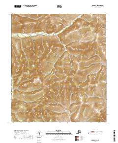
2019 Map of Medfra D-1 NE
USGS Topo · Published 2019About this map
The Sischu Mountains dominate this interior landscape in the Yukon-Koyukuk region of Alaska. This 2019 survey documents a wilderness terrain defined by its complex drainage systems and significant elevation changes. Waterways such as Sischu Cr and Lind Cr carve through the mountain slopes, illustrating the natural hydrological patterns of the northern interior. The map clearly delineates township and range lines across several sections, including t17s r29e and t18s r30e, providing a precise grid for understanding this undeveloped territory. For those studying the geography of the Alaska interior, the map offers an exacting look at the landform shapes and remote stream networks that define this part of the state.
Find a feature on this map
12 named features on this map. Tap any name to fly to it.
Don’t see what you’re looking for? This feature index may not catch every label — zoom into the map to look around manually.
Map Details
Editions of this 2019 Medfra D-1 NE Map
This is the sole edition of this map. No revisions or reprints were ever made.
Other maps of this area

1948 · Kantishna River
USGS Topo · 1:250,000

1950 · Medfra
USGS Topo · 1:250,000

1951 · Kantishna River
USGS Topo · 1:250,000

1951 · Ruby
USGS Topo · 1:250,000

1952 · Mount McKinley
USGS Topo · 1:250,000

1952 · Ruby A-1
USGS Topo · 1:63,360

1952 · Kantishna River
USGS Topo · 1:250,000

1952 · Kantishna River A-6
USGS Topo · 1:63,360

1952 · Ruby
USGS Topo · 1:250,000
1953 · Kantishna River A-6
USGS Topo · 1:63,360