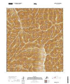
2019 Map of Medfra D-5 NE
USGS Topo · Published 2019About this map
Sunrise Creek and Sunset Creek define the primary drainage patterns of this Alaskan interior landscape in the Yukon-Koyukuk Census Area. The terrain is characterized by a series of high ridges and narrow valleys, mapped with ten-foot contour intervals to illustrate the complex relief between these two water bodies. The Public Land Survey System grid identifies several townships, including t17s r19e, t18s r19e, and t19s r19e, which mark the systematic division of this remote territory. While the map is devoid of structures or road networks, the relative positions of the creeks indicate a landscape of high-elevation drainages typical of the Alaska Range foothills.
Find a feature on this map
8 named features on this map. Tap any name to fly to it.
Don’t see what you’re looking for? This feature index may not catch every label — zoom into the map to look around manually.
Map Details
Editions of this 2019 Medfra D-5 NE Map
This is the sole edition of this map. No revisions or reprints were ever made.
Other maps of this area

1950 · Medfra
USGS Topo · 1:250,000

1951 · Ruby
USGS Topo · 1:250,000

1952 · Ruby A-4
USGS Topo · 1:63,360

1952 · Ruby A-5
USGS Topo · 1:63,360

1952 · Ruby
USGS Topo · 1:250,000

1954 · Medfra D-5
USGS Topo · 1:63,360
1954 · Medfra D-4
USGS Topo · 1:63,360

1959 · Medfra
USGS Topo · 1:250,000

1964 · Ruby
USGS Topo · 1:250,000
2019 · Medfra D-5 SW
USGS Topo · 1:25,000