
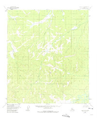
1952 Map of Ruby A-4
USGS Topo · Published 1957About this map
The Nowitna River meanders through the southeastern corner of this Alaskan interior landscape, anchoring a complex drainage network that defines the region's topography. The area is characterized by the confluence of several significant watercourses, including the Lost River and Bonanza Creek, which carve through the elevations of the Ruby quadrangle. Survey control points like VABM 2132 Lost provide a glimpse into the mid-century mapping efforts conducted by the Geological Survey using 1952 aerial photography. Other drainages such as Straight Creek, Wood Creek, and Little Moose Creek indicate a land shaped entirely by its hydrology, where no roads or established trails existed at the time of the survey, highlighting the pristine and untouched character of the Fourth Judicial Division during this era.
Find a feature on this map
7 named features on this map. Tap any name to fly to it.
Don’t see what you’re looking for? This feature index may not catch every label — zoom into the map to look around manually.
Map Details
Editions of this 1952 Ruby A-4 Map
2 editions found
Other maps of this area

1950 · Medfra
USGS Topo · 1:250,000

1951 · Ruby
USGS Topo · 1:250,000

1952 · Ruby A-3
USGS Topo · 1:63,360

1952 · Ruby B-4
USGS Topo · 1:63,360

1952 · Ruby B-3
USGS Topo · 1:63,360

1952 · Ruby B-5
USGS Topo · 1:63,360

1952 · Ruby A-5
USGS Topo · 1:63,360

1952 · Ruby
USGS Topo · 1:250,000
1953 · Ruby B-3
USGS Topo · 1:63,360

1954 · Medfra D-5
USGS Topo · 1:63,360