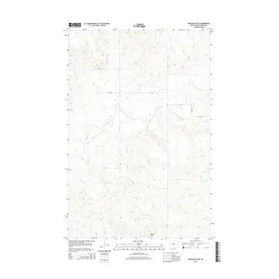
2014 Map of Medicine Butte
USGS Topo · Published 2014About this map
Medicine Butte dominates the southern skyline of this Mercer County landscape, serving as a prominent landmark in a region defined by the meandering Knife River. The river winds through the central portion of the territory, joined by tributaries such as Mud Cr and Coyote Cr. This 2014 survey illustrates the section-line road grid typical of the Great Plains, where routes like Cr-11 and Cr-13 provide the primary framework for movement across the open terrain. The map captures the intersection of natural drainage systems and human-imposed boundaries, showing how the local road network, including 14th St SW, adapts to the river's path and the elevation of the butte.
Find a feature on this map
11 named features on this map. Tap any name to fly to it.
Don’t see what you’re looking for? This feature index may not catch every label — zoom into the map to look around manually.
Map Details
Editions of this 2014 Medicine Butte Map
This is the sole edition of this map. No revisions or reprints were ever made.
Other maps of this area

1953 · Watford City
USGS Topo · 1:250,000

1954 · McClusky
USGS Topo · 1:250,000

1957 · Watford City
USGS Topo · 1:250,000

1958 · McClusky
USGS Topo · 1:250,000

1967 · Watford City
USGS Topo · 1:250,000

1968 · Beulah
USGS Topo · 1:24,000

1968 · Medicine Butte NE
USGS Topo · 1:24,000

1968 · Medicine Butte
USGS Topo · 1:24,000

1969 · Zap
USGS Topo · 1:24,000
1972 · Medicine Butte SW
USGS Topo · 1:24,000