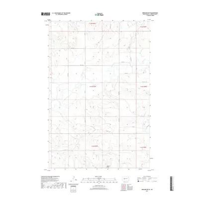
2017 Map of Medicine Butte
USGS Topo · Published 2017About this map
Medicine Butte dominates the southern landscape of this Mercer County region, providing a prominent natural landmark in a territory defined by the winding course of the Knife River. This 2017 survey reveals a rural landscape strictly organized by the Public Land Survey System, with gravel roads like Co Rd 11 and Co Rd 13 following section lines across the prairie. The drainage of Mud Cr feeds into the larger river system, illustrating the subtle hydrology that dictated early ranching and agricultural patterns. This map is particularly useful for researchers tracing land ownership and the modern grid of section-line roads, such as 14th St SW and 66th Ave SW, which intersect the open range once traversed by earlier North Dakota settlers.
Find a feature on this map
22 named features on this map. Tap any name to fly to it.
Don’t see what you’re looking for? This feature index may not catch every label — zoom into the map to look around manually.
Map Details
Editions of this 2017 Medicine Butte Map
This is the sole edition of this map. No revisions or reprints were ever made.
Other maps of this area

1953 · Watford City
USGS Topo · 1:250,000

1954 · McClusky
USGS Topo · 1:250,000

1957 · Watford City
USGS Topo · 1:250,000

1958 · McClusky
USGS Topo · 1:250,000

1967 · Watford City
USGS Topo · 1:250,000

1968 · Beulah
USGS Topo · 1:24,000

1968 · Medicine Butte NE
USGS Topo · 1:24,000

1968 · Medicine Butte
USGS Topo · 1:24,000

1969 · Zap
USGS Topo · 1:24,000
1972 · Medicine Butte SW
USGS Topo · 1:24,000