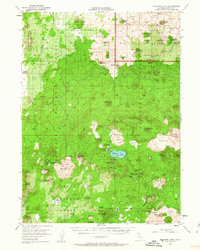
1952 Map of Medicine Lake
USGS Topo · Published 1963About this map
Medicine Lake sits at the center of this volcanic highland, surrounded by a complex landscape of shield volcanoes and expansive lava flows. The 1952 field check documents an era of resource extraction and fire management across four different national forests, including the Modoc National Forest and Klamath National Forest. Massive obsidian and rhyolite features like Glass Mountain and Little Glass Mountain dominate the terrain, while the northern section includes the rugged basaltic formations of Lava Beds National Monument.
Find a feature on this map
82 named features on this map. Tap any name to fly to it.
Don’t see what you’re looking for? This feature index may not catch every label — zoom into the map to look around manually.
Map Details
Editions of this 1952 Medicine Lake Map
4 editions found
Other maps of this area

1886 · Modoc Lava Bed
USGS Topo · 1:250,000

1892 · Modoc Lava-Bed
USGS Topo · 1:250,000

1932 · Bartle
USGS Topo · 1:96,000

1939 · Bartle
USGS Topo · 1:125,000

1950 · Mt. Dome
USGS Topo · 1:62,500

1950 · Bray
USGS Topo · 1:62,500

1950 · Dorris
USGS Topo · 1:62,500

1951 · Tulelake
USGS Topo · 1:62,500

1952 · Timber Mountain
USGS Topo · 1:62,500

1952 · Medicine Lake
USGS Topo · 1:62,500